Revisiting 1868 to Inform Disaster Preparedness - 5/6: Maunaloa Erupts at Kahuku

Maps of Maunaloa’s summit before and after the events of 1868, showing an enlarged crater presumably due to collapse during the sequence. Four years following the collapse, lava returned to Maunaloa summit and began filling its deepest craters, such that the 1874 shows a flat crater floor at its center. Kīlauea has recently undergone a similar transformation, where six years following its summit collapse, its inner crater has been largely refilled to a flat crater floor within an enlarged area of subsidence. Maps by Thomas Jaggar from The Volcano Letter, Nov. 19, 1931.
The series of disasters on Hawaiʻi Island between March 27 and April 11, 1868 includes the largest earthquake ever reported in Hawaiʻi, estimated at magnitude 7.9, to go along with two other magnitude 7’s and countless smaller events, devastating landslides and tsunamis, four eruptions in total at both Maunaloa and Kīlauea volcanoes’ summits and southwest rifts, and finally significant collapses atop each volcano. If such a sequence were to repeat today, residents’ knowledge and preparedness could go a long way in mitigating its impact, especially in minimizing the damage to human lives and well-being. In that spirit, we present a series of 6 short articles that recap each phase of the sequence and its relevance to those of us on-island.
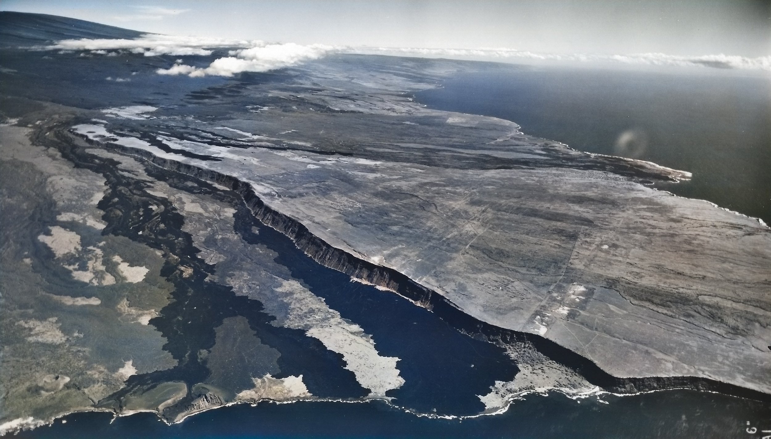
Aerial photo of the lower part of the 1868 eruption, where its dark lava flows meet the sea south-southwest of their source. Maunaloa’s upper reaches are at the top left of the image, while Kalae (the island’s “South Point”) is just off the image to the right. USGS photo taken in 1954, from the USGS Volcano Watch article on April 5, 2018, colorized with Capcut AI.
Today, we examine the fifth and final phase of the sequence, Maunaloa’s eruption on its Lower Southwest Rift and its own summit collapse. During the first phase, Maunaloa erupted briefly at its summit, intruded its Southwest Rift, and triggered a magnitude 7.1 quake on March 28. In the second phase, a magnitude 7.9 quake on April 2 caused widespread damage, collapses, landslides, a freak mudflow and a tsunami, through which altogether perhaps 100 people perished. In the third phase, the Great Quake triggered the draining of lava from Kīlaueaʻs summit and intrusion into the rift zone(s) accompanied by many earthquakes, along with a brief eruption within Kīlauea Iki. In the fourth phase, another magnitude 7 quake rocked Kīlauea, opening its Southwest Rift further to feed a small eruption and cause collapse at Kīlauea summit.
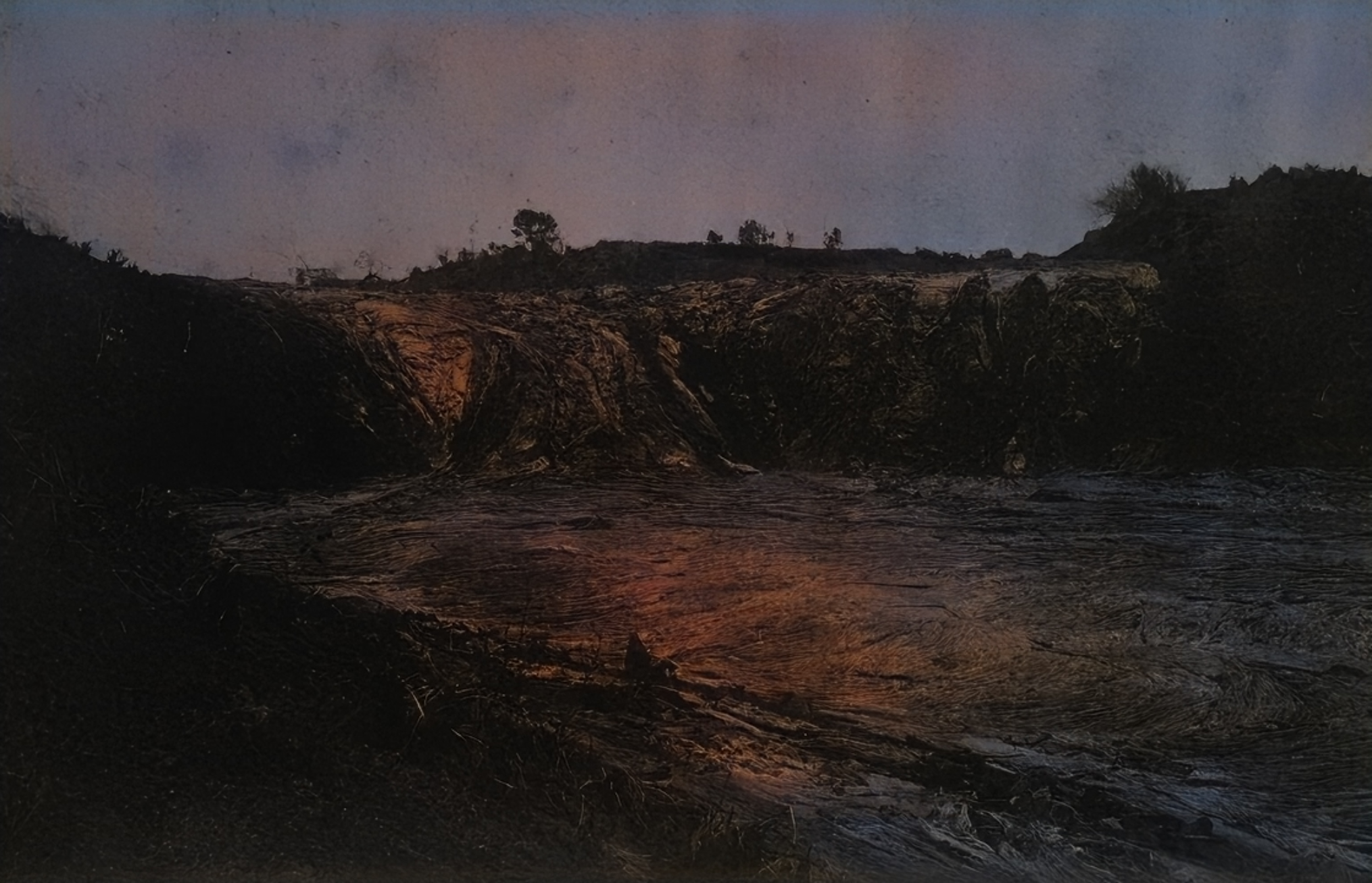
Part of the 1868 flow at Kahuku, where lava cascaded down a steep slope. Photo by H. L. Chase from the Mission Houses Museum Archive via Wikimedia Commons, restored with Capcut AI.
Kaʻū had been quieter for several days following the Great Quake and its immediate aftershocks, but on April 6 the shaking intensified again. Many people slept outside that night, fearful of houses damaged by countless earthquakes coming down upon them. Fine ash is reported to have fallen overnight, well before the eruption of any lava.
It seems likely that Maunaloa’s summit began to collapse at some point following the Great Quake, intensifying on April 6 with renewed seismicity. As we experienced on Kīlauea in 2018, the collapses and accompanying quakes probably lasted until the end of the coming eruption, which was to be April 11. According to preliminary work by the USGS Hawaiian Volcano Observatory, despite that relatively short time, the collapse of Maunaloa in 1868 may have been larger than that of Kīlauea in 2018 which took a full 3 months to complete. Maps from before and after the collapse illustrate the enlargement of Maunaloa’s caldera, Mokuʻāweoweo, though the innermost collapse craters were refilled by subsequent eruptions (also similar to Kīlauea since 2018).
Finally, Maunaloa’s magma would re-emerge at Kahuku on April 7, 1868, 11 days after first triggering the cascade of events. The eruption began around the 3,000-foot elevation, more than 10,500 feet below Maunaloa summit, fed by magma moving into the Southwest Rift from beneath the summit above. Fissures emerged upslope of the residence of Captain Brown, near where a crater 60 feet wide issuing steam and sulfurous gases had formed earlier in the sequence. Lava quickly overran the farm and what remained of its structures damaged by the earthquakes. The fissure line would grow to over two miles long, with four distinct lava fountains over 500 feet high established over the coming days. Lightning and thunder accompanied the eruption, and vog was widespread with the whole island “shrouded in darkness” according to the Pacific Commercial Advertiser. The massive volume of gas emitted was noted to be larger than that produced throughout the much longer 1859 eruption, still fresh on people’s minds.

USGS map of the 1868 lava flow along with other historic lava flows from Maunaloa in the southern part of Hawaiʻi Island. From USGS Volcano Watch article, May 19, 2022.
The eruption spawned lava flows that split into several branches, some flowing southeast and some southwest. The largest became a huge river of lava which reached the ocean 10 miles away in only three and a half hours, generating furious ocean entries with explosions that formed a littoral cone. Several close calls and miracle escapes were had, but ultimately there were no human casualties unlike the week before. The eruption lasted 5 days, allowing a few off-island visitors just enough time to travel to Kaʻū to witness flowing lava. Their accounts make this phase the best documented of the whole sequence, after which the destruction included 37 houses and over 100 livestock while covering over 1.5 miles of public roads. Following the eruption, steaming cracks were noted to continue upslope from the fissures to a distance of 10 miles, but finally the worst of the earthquakes were over, and Kaʻū residents could finally rest and begin to recover.
What can we learn today from the harrowing events of 1868? That will be the topic of our final article in this series, as we consider the challenge of one of our worst-case series of disasters and use that to improve our preparedness today.
#Maunaloa #Geology #Hawaii #1868Eruption #HawaiiHistory
–
Note: We use a preferred traditional spelling of the volcano by the local community as “Maunaloa”, though it has not yet been formally adopted by either the State or Federal Board of Geographic Names who still officially refer to it as “Mauna Loa”. This follows in the same spirit as the spelling of “Maunakea” gaining broader acceptance.