Revisiting 1868 to Inform Disaster Preparedness - 3/6: Kaʻū Quake Triggers Kīlauea

Kīlauea as painted by Tavernier after a large earthquake affected lava lakes at the summit in 1885, perhaps a similar view to the draining lava in 1868. Image from USGS Open-File Report 2018-1027.
The series of disasters on Hawaiʻi Island between March 27 and April 11, 1868 includes the largest earthquake ever reported in Hawaiʻi, estimated at magnitude 7.9, to go along with two other magnitude 7’s and countless smaller events, devastating landslides and tsunamis, four eruptions in total at both Maunaloa and Kīlauea volcanoes’ summits and southwest rifts, and finally significant collapses atop each volcano. If such a sequence were to repeat today, residents’ knowledge and preparedness could go a long way in mitigating its impact, especially in minimizing the damage to human lives and well-being. In that spirit, we present a series of 6 short articles that recap each phase of the sequence and its relevance to those of us on-island.

Annotated photo of Kīlauea Iki circa 1901, showing the extent of the 1868 flow on the floor of Kīlauea Iki crater. Restored with Capcut AI from Figure 9a of Orr, T. R., Hazlett, R., DeSmither, L., Kauahikaua, J., & Gaddis, B. (2021). Correcting the historical record for Kīlauea Volcano's 1832, 1868, and 1877 summit eruptions. Journal of Volcanology and Geothermal Research, 410, 107168.
Today, we examine the third phase of the sequence, the initial effects on Kīlauea resulting from the Great Kaʻu Earthquake. During the first phase, Maunaloa erupted briefly at its summit, intruded its Southwest Rift, and triggered a magnitude 7.1 quake on March 28. In the second phase, a magnitude 7.9 quake on April 2 caused widespread damage, collapses, landslides, a freak mudflow and a tsunami, through which altogether perhaps 100 people perished.
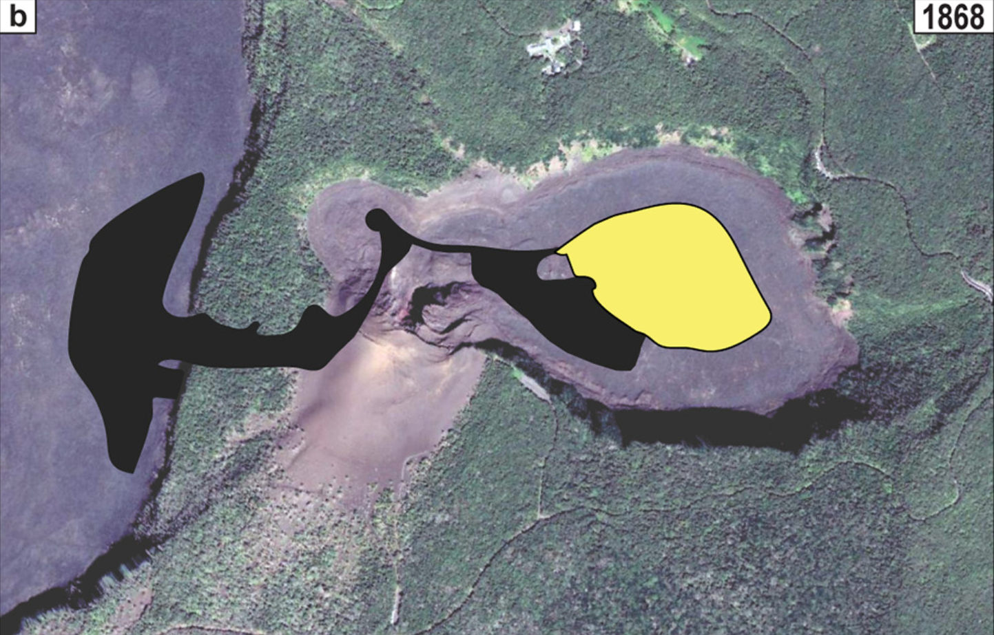
Map view of the extent of the 1868 flow shown in yellow on the floor of Kīlauea Iki crater. Figure 2b from Orr, T. R., Hazlett, R., DeSmither, L., Kauahikaua, J., & Gaddis, B. (2021). Correcting the historical record for Kīlauea Volcano's 1832, 1868, and 1877 summit eruptions. Journal of Volcanology and Geothermal Research, 410, 107168.
Although records of events on Kīlauea during this time are sparse and sometimes ambiguous, we can reconstruct a potential sequence of events informed by recent science and observations. The initial effects on Kīlauea likely date back to the earlier 7.1 quake, with collapse along the southwest rim. Following the Great Earthquake on April 2, further widespread cliff collapses were reported, and a short eruption occurred on the floor of Kīlauea Iki from the pressure on cooling magma underground. Modern chemical analysis by Garcia, Pietruszka, and Rhodes (2003) suggests the source magma for the Kīlauea Iki eruption had evolved for several decades, perhaps from the 1832 eruption 36 years prior, rather than being fed by fresher, hotter magma. Within the main active lava lakes at Halemaʻumaʻu, the nature of the eruption began to change as lava subsided and reduced in area, progressing over the next 5 days, at which point lava was no longer visible on Kīlauea.

“The Kīlauea Iki 1868 lava falls off the coherent temporal trend for Kīlauea lavas. This evolved lava may have been related to early 19th century magma as shown by arrow.” Figure 12 from Garcia, M.O., Pietruszka, A.J., & Rhodes, J.M. (2003). A Petrologic Perspective of Kīlauea Volcano's Summit Magma Reservoir. Journal of Petrology, 44, 2313-2339.
Over this time, the lava was draining somewhere, likely into one of Kīlauea’s rift zones widened by the 7.9 event. Numerous smaller earthquakes would have tracked the migration of magma within the volcano, as we have seen in a recent eruption in 2018 on the East Rift and in a recent intrusion in 2023-24 on the Southwest Rift. In 1868, a vague report of “eastern craters opening and smoke in the direction of Puna”, as put by USGS Professional Paper 1806, suggests the possibility of an East Rift intrusion somewhere during this time. Complicating matters, a fire was also separately reported in Puna during this time, perhaps but not noted to be related to the earthquake.
However, as Kīlauea’s Southwest Rift actually did erupt at an unknown time within the next few days, it seems a likely candidate for the intrusion responsible for summit draining. Perhaps the intrusion led to what came two days later, when another earthquake around magnitude 7 further opened the Southwest Rift. While we interpret those two events into the next phase of the sequence, a conclusive determination is difficult because later reports of damage and subsidence integrate both those events and the earlier magnitude 7.9. That will be the topic of our next article in this series, as we consider the challenge of one of our worst-case series of disasters and use that to improve our preparedness today.
#Maunaloa #Geology #Hawaii #1868Eruption #HawaiiHistory