Kīlauea’s 1954 Eruption
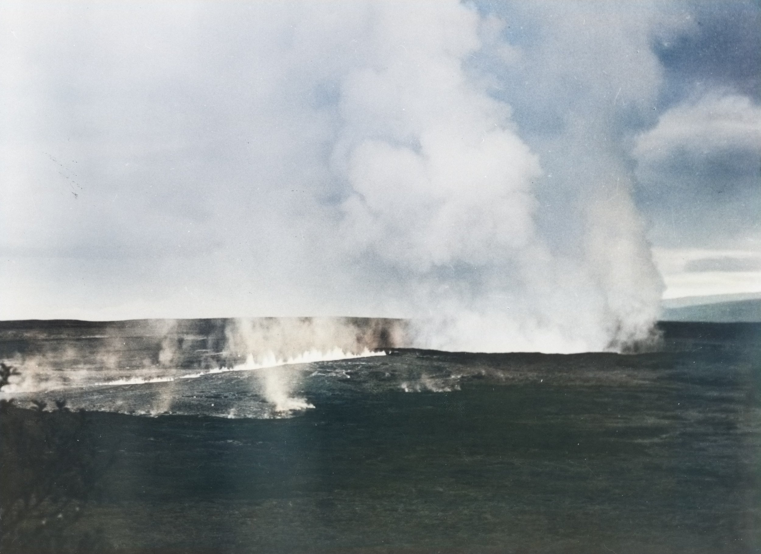
Line of Lava Fountains to Halemaʻumaʻu. 1954 eruption featuring a line of lava fountains leading to Halemaʻumaʻu crater, as viewed from the north side of Kīlauea caldera. NPS Photo/Ralph T. Kanemori (HAVO 17707 Image Collection; Box 27, Folder 7, Image 003). Colorized with CapCut AI.
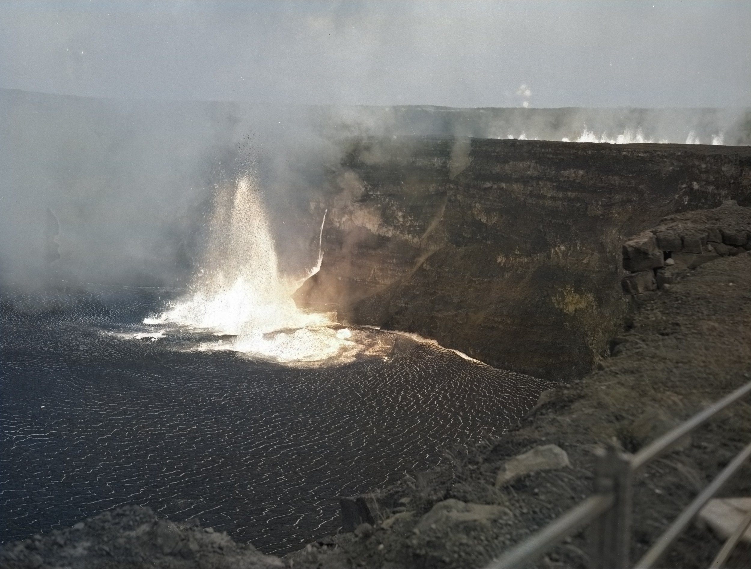
1954 Eruption in Halemaʻumaʻu Crater, May 31. Fountains and a [300-foot] lava fall down the wall of Halemaʻumaʻu crater during the 1954 eruption. NPS Photo/Ralph T. Kanemori (HAVO 17707 Image Collection; Box 24, Folder 1, Image 270). Colorized with CapCut AI.
Kīlauea’s May 31, 1954 eruption, 70 years ago today, offers one possible example of how a future summit eruption could look. Although the eruption technically lasted 3 ½ days, most lava erupted within the first 2 hours, flooding the inner crater floor with a 63-foot-deep lava lake while also paving 139 acres of the main caldera floor.
It was a hectic start to the morning for HVO scientists Gordon Macdonald and Jerry Eaton, roused by earthquakes at 3:42 AM and 3:47 AM. It had been over 18 months since the previous eruption in 1952. “Shortly afterward Macdonald noticed a faint, persistent low-pitched roaring, almost a felt vibration rather than a recognizable sound, somewhat resembling the vibration caused by a heavy truck in low gear climbing a distant hill. The sensation continued as long as the observer remained motionless.”

Southwest Fountain in Halemaʻumaʻu. To the right small fountains are playing along fissures that cross the 1952 cones. The bright lines on the crater floor are cracks in the dark lava crust, revealing the incandescent material beneath. Taken from the eastern rim about 6:30 AM on May 31, 1954. Photograph by Ralph T. Kanemori, Modern Camera Center, Hilo. From USGS Bulletin 1061-B, Plate 2B.
After another moderate earthquake at 3:51 AM, a violent quake at 3:54 AM rendered the main seismograph inoperable, and the scientists rushed to repair it. They restored it to function at 4:08 AM, just in time to see the onset of volcanic tremor at 4:09 AM, at which point they ran outside and saw the bright glow of the new eruption. They hustled to the observatory and shortly thereafter made their way onto the caldera floor to make observations.
Fissures had opened across the floor of Halemaʻumaʻu diagonally from east-northeast to west-southwest, with 3 parallel rows of smaller fountains in the center anchored by a southwest fountain 250 to 300 feet high and by a northeast fountain between 550 and 600 feet high that peaked 100 feet above the crater rim. The principal fissure bisected the cones left from the 1952 eruption. Around 4:30 AM, another set of fissures opened on the main caldera floor, throwing lava up to 100 feet high, extending to 1400 feet long over the next 20 minutes, and issuing lava flows up to 1000 feet long.

1954 Lava Lake Within Halemaʻumaʻu Crater, May 31. Erupting lava lake in Halemaʻumaʻu with multiple fountaining and degassing sites. USGS Photo/ J.P. Eaton
“Possibly the most spectacular feature of the eruption was the cascade of brilliant orange-yellow lava that poured from the eruptive fissure 300 feet above the floor, on the northeastern wall of the crater. Plunging down the wall, this ‘fire-fall’ of incandescent liquid joined the turbulent pool around the base of the northeastern fountain. The lava issued at the head of the cascade quietly, with little spattering and no fountaining, as though it were poor in gas. At the base of the cascade a row of small fountains issued from the eruptive fissure, merging southward with the big northeast fountain.”

1954 Lava Lake Within Halemaʻumaʻu Crater. Close up of the erupting lava lake with multiple fountaining and degassing sites. USGS Photo/ J.P. Eaton
“No conspicuous crack was visible on the wall of Halemaʻumaʻu above the head of the cascade, or between the rim of Halemaʻumaʻu and the end of the fountain chain to the east. In the latter gap there were many cracks in a zone about 50 feet wide along the projected course of the eruptive fissure farther east, but none of them was continuous for more than a few feet, or was more than 2 or 3 millimeters wide.”
The eruption peaked around 6:45 AM, with new lava averaging 63 feet deep and “nearly burying the cones of the 1952 eruption.” Sulfurous gas emissions were noted throughout, and heat from the lava lake led to “small, violent whirlwinds [that] caused dustdevils around the edge of the crater, and whirled across the crater floor, carrying fragments of the thin crust of the lava lake.” At 7:30 AM, activity was decreasing across all fountains and fissures.

Parking Lot Near Halemaʻumaʻu Crater. Cars parked at a scenic overlook. NPS Photo/Ralph T. Kanemori (HAVO 17707 Image Collection; Box 24, Folder 1, Image 276). Colorized with CapCut AI.
By 10 AM, activity was mainly confined to the northeast and southwest fountains in Halemaʻumaʻu, with the area around the 1952 cones hosting a sinkhole and occasionally bursting lava. Around 12 PM, “a rapid sinking of the lava level began over the entire floor of Halemaʻumaʻu, leaving a narrow band of congealed lava clinging to the crater walls.” By the following morning, the slump scarp had grown to an average height of 32 feet. Fissures on the caldera floor reactivated briefly at 1:30 PM with weak spattering, but shut off completely by 4 PM.
By evening, the activity consisted mostly of intermittent small explosions of red-hot cinders and incandescent ejecta from various vents along the fissure within Halemaʻumaʻu. The next day, June 1, a 2-foot tall lava fountain fed small flows onto the northeast part of the crater floor, building up a small pond about 300 feet long and 100 feet wide over the fissure that lasted until June 3. Weak blasts from fissure vents ended about 6 PM that evening, marking the full 3 ½ days.
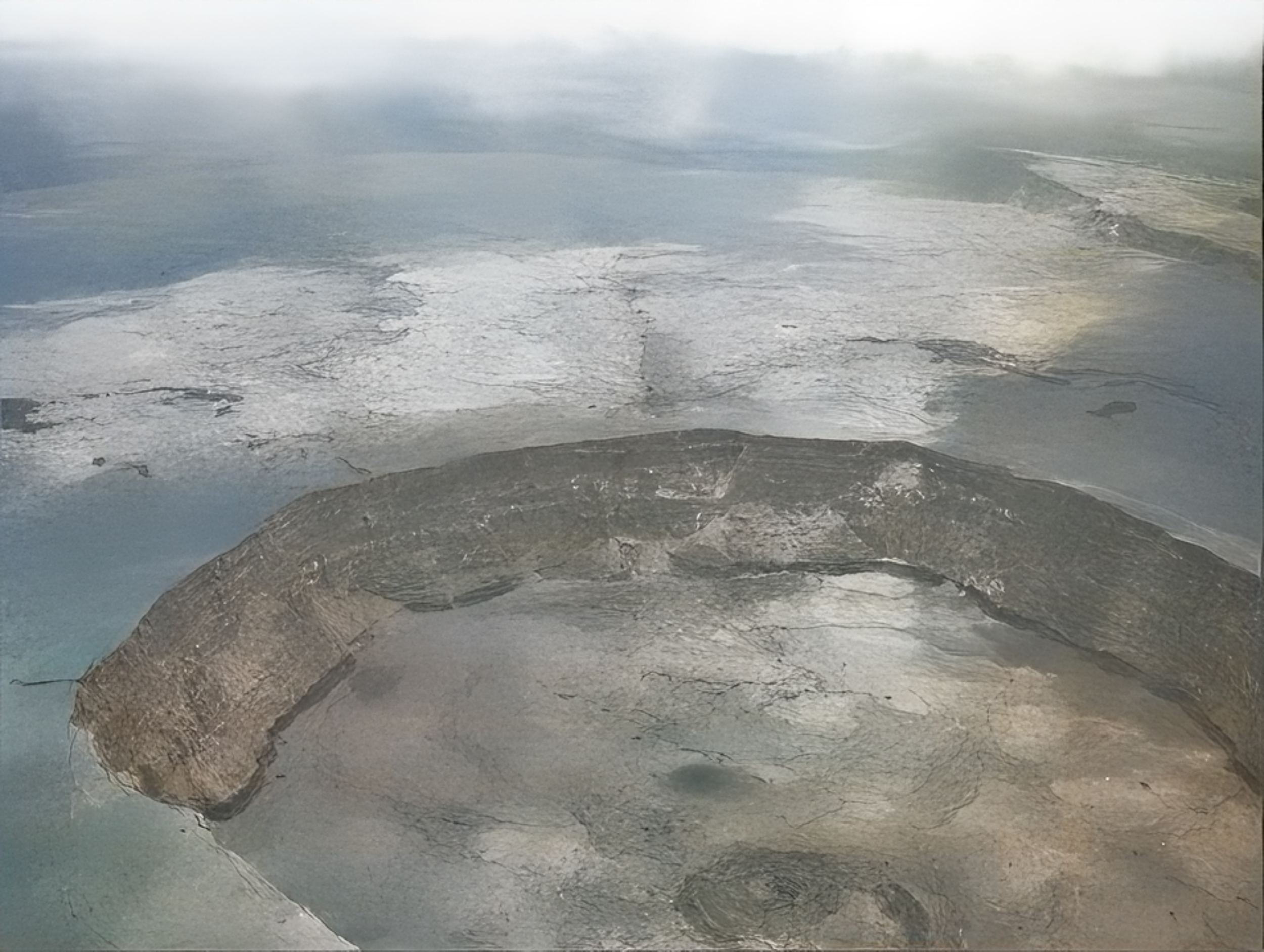
Aerial of Halemaʻumaʻu Crater in 1954, June 5. Aerial image of Halemaʻumaʻu crater after 1954 eruption. NPS Photo/Field & Bohlin (HAVO 17707 Image Collection; Box 24, Folder 1, Image 285). Restored with CapCut AI.
In the end, about 16.5 million cubic yards of lava had been erupted, but 8 million drained back underground after the first 8 hours. Still, an average thickness of 31 feet of lava remained within Halemaʻumaʻu after the eruption, eventually to be buried by more lava in later years. Portions of the lava flow on the main caldera flow were also subsequently covered, but a large swathe of it survived into 2018 and through the summit collapse, riding the large eastern down-dropped block. The September 2023 eruption drastically reduced the remaining area of the 1954 flow, but a large piece of it still survives just below the northeastern crater wall today, with two smaller coat-tail pieces still clinging to the upper rim.
While the 1954 eruption and similar summit activity poses little increased threat to people, it serves to educate us about the range of possible scenarios Kīlauea can create. As we prepare Hawaiʻi Island to be more resilient in the face of the next destructive eruption, we use such examples to continually learn the patterns of how the volcano behaves, such that we can more accurately convey information and make better and faster decisions the next time lava enters one of our communities.
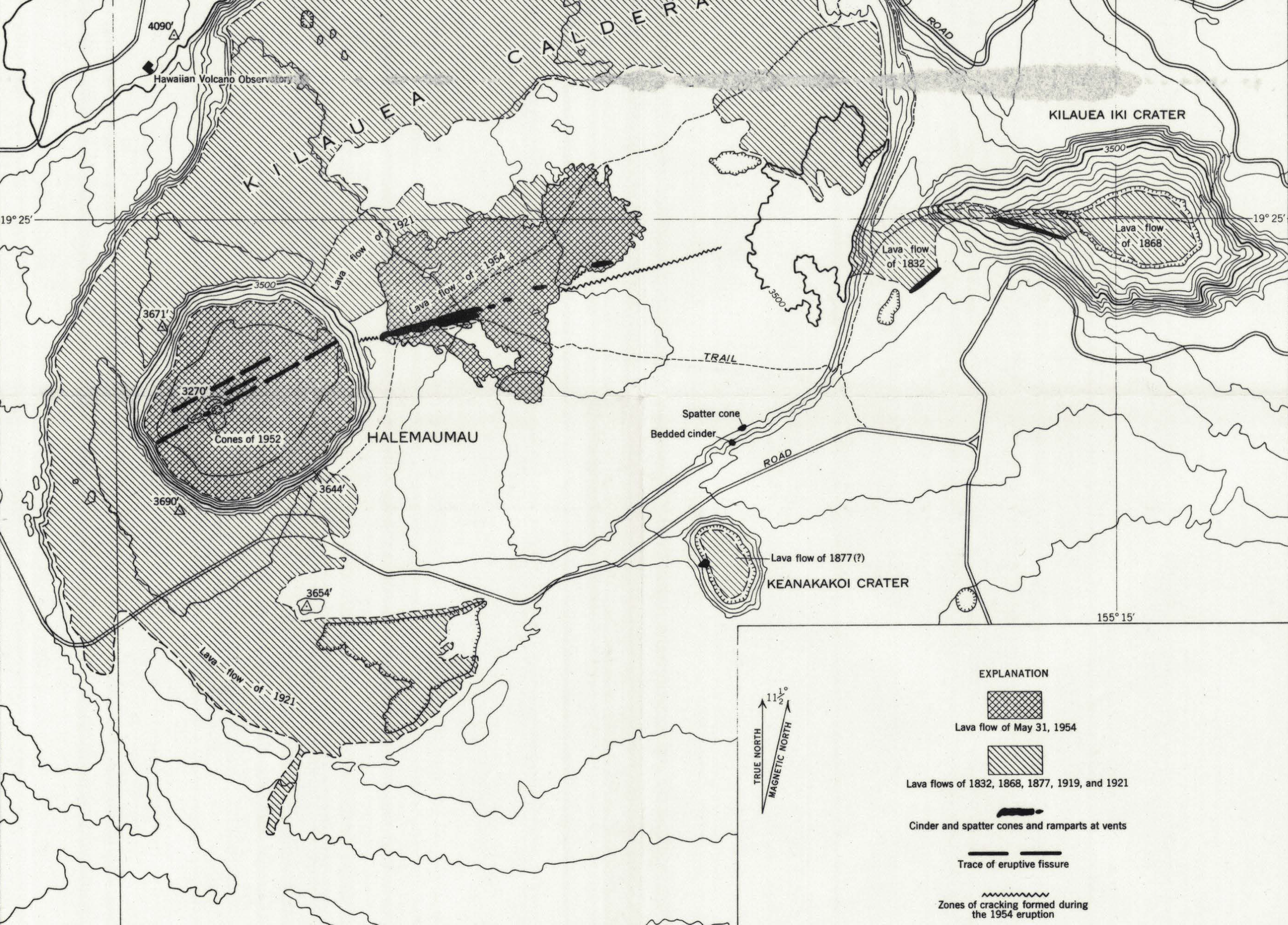
Map of Kīlauea Caldera showing location of eruptive fissures and lava flow of the 1954 eruption, and some older flows outside Halemaʻumaʻu. From USGS Bulletin 1061-B, Plate 1.

Geologic map of Halemaʻumaʻu updated to May 2024, overlaying the recent eruption footprints of June and September 2023 on the post-2018 collapse geologic map. September 2023 flow area is translucent to indicate recently covered lava flows. All map components compiled by HVERI from releases by the USGS Hawaiian Volcano Observatory.