Introducing the Island of Hawaiʻi Interagency Operations Plan for Volcanic Eruptions — USGS Volcano Watch
Last month, the Hawaiʻi County Civil Defense Agency, Hawaiʻi Volcanoes National Park, and the U.S. Geological Survey (USGS) Hawaiian Volcano Observatory (HVO) adopted the Island of Hawaiʻi Interagency Operations Plan for Volcanic Eruptions (hereafter referred to as the Interagency Volcano Plan).
While our three agencies have worked well responding to volcanic unrest and eruptions together for decades, the Interagency Volcano Plan puts our practices down on paper. We have developed it when our volcanoes have been relatively quiet—away from the stress of a crisis response—to make deliberate choices and decisions on how we can best serve our community and visitors to the Island of Hawaiʻi going forward, strengthening the partnership between the three agencies in the process.
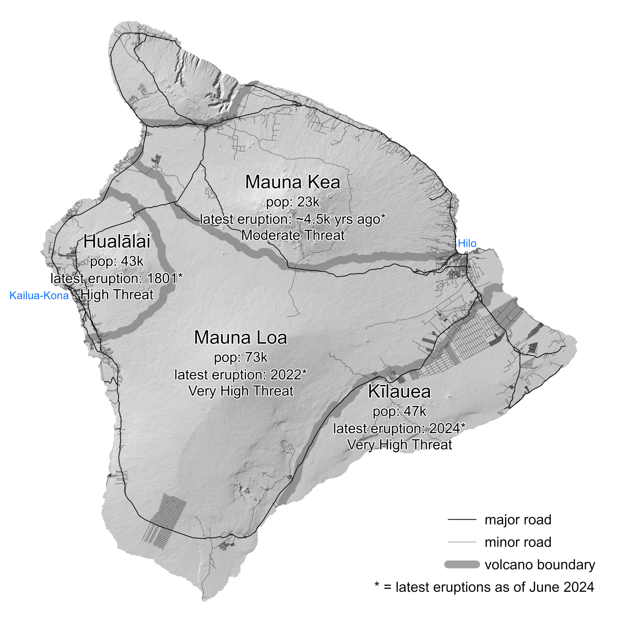
Map of Island of Hawaiʻi, highlighting the four active or potentially active volcanoes of the Island, the number of people living on each volcano based on 2020 census data, major roads (transportation corridors) and minor roads (proxy for population density), when each volcano last erupted, and each volcano’s national threat assessment designation.
Why is the Interagency Volcano Plan needed? The Island of Hawai’i consists of five volcanoes. Four volcanoes (Kīlauea, Mauna Loa, Hualālai, and Mauna Kea) are considered active and three of them have erupted since the year 1800. Based on 24 factors including eruptive history, eruptive style and associated hazards, and population exposure, the 2018 Update to the U.S. Geological Survey National Volcanic Threat Assessment identified Kīlauea and Mauna Loa as very high threat volcanoes, Hualālai as a high threat volcano, and Mauna Kea as a moderate threat volcano. For context, there are only 18 very high threat volcanoes in the United States.
Volcanic eruptions in Hawaii can profoundly impact local communities, infrastructure, human health, agriculture, businesses, and tourism. A well-coordinated volcanic incident response can minimize loss of life, injury, social and economic disruption, and long-term consequences. This requires timely, accurate, relevant, and trusted information to threatened and impacted communities, and to the general population for situational awareness.
In 2018, lava flows from the lower East Rift Zone of Kīlauea destroyed 612 residences. At Kīlaueaʻs summit, Hawaiʻi Volcanoes National Park and neighboring communities were affected by thousands of earthquakes as the summit incrementally collapsed over the course of three months during the same eruption. In 2022, Mauna Loa erupted for the first time in 38 years; fortunately, the impacts were minimal. HVO monitored these volcanic events, working closely with landholding agencies such as the Hawaiʻi Volcanoes National Park, and emergency managers, led by the Hawaiʻi County Civil Defense Agency.
The Interagency Volcano Plan draws on the formal and informal USGS after-action reviews for the 2018 Kīlauea and 2022 Mauna Loa eruptions, respectively, to improve planning and response protocols. The development of the Interagency Volcano Plan spanned nearly two and a half years—interrupted by Covid-19 outbreaks, 6 eruptions, and other emergency responses—building on regular discussions between the three agencies on how to best work together during volcanic crises. It draws from elements of other USGS volcano observatories’ interagency coordination plans but is uniquely developed for the Island of Hawaiʻi.
The Interagency Volcano Plan addresses volcanic unrest and eruption response coordination on the Island of Hawaiʻi. Unrest hazards may include seismicity, ground deformation (including ground cracks and subsidence), volcanic gases and air pollution (vog), and associated hazards. Not all unrest leads to an eruption. Eruptive hazards may include all the unrest hazard and also active vents (including fissures), lava flows, lava bombs, tephra fall (including ash), laze, and (rare in Hawaii) pyroclastic density currents.
The Interagency Volcano Plan is intended to be a guide, as each volcanic incident is unique. It is supported by detailed Standing Operating Guidelines and/or Standing Operating Procedures maintained by each participating agency. The Interagency Volcano Plan documents how the three agencies work together during volcanic crises, with the understanding that circumstances may require situation-specific changes and adaptations. It covers the roles and responsibilities of each agency, how notification of a volcanic situation is completed, jurisdictional areas of responsibility, incident command, information flow, and aviation coordination.
The three agencies that are part of this first version of the Interagency Volcano Plan are based on the Island of Hawaiʻi and were identified as having the most significant opportunities to improve interagency coordination in the USGS 2018 Kīlauea eruption after-action review. Additional agencies will be incorporated in future versions of the Interagency Volcano Plan, and work on version 2 is slated to start in October 2025.
Volcano Watch is a weekly article and activity update written by U.S. Geological Survey Hawaiian Volcano Observatory scientists and affiliates. This week’s article, which was written by HVO geologist Natalia Deligne. This week’s article, which was written by HVO geologist Natalia Deligne, is being delivered one day late due to HVO website maintenance. Posting of this article on the HVO website will be delayed.