A look back at recent Kīlauea eruptions and intrusions — USGS HVO Volcano Watch
Following the 2018 lower East Rift Zone eruption and summit collapse, Kīlauea summit earthquake rates were higher overall compared to before the 2018 eruption. In March of 2019, the summit magma chamber began inflating again, and in July, water appeared at the bottom of the Halema‘uma‘u crater collapse pit, which grew into a lake over the next year and a half. But this break from eruptions and intrusions at Kīlauea was relatively short, lasting just over two years.
Sources/Usage: Public Domain
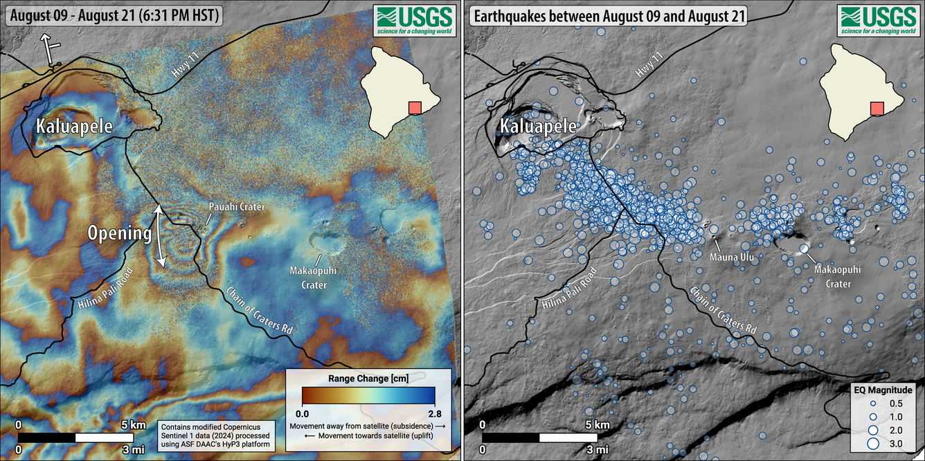
The map on the left shows deformation at Kīlauea from August 9–21, 2024. Data were acquired by the European Space Agency's Sentinel-1A satellite. Colored fringes denote areas of ground deformation, with more fringes indicating more deformation. Each color cycle represents 2.8 cm (1.1 in) of ground motion. The butterfly-shaped feature near Pauahi Crater on the upper East Rift Zone indicates ground surface motion over this time period as magma intruded underground. The map on the right shows earthquakes over the same timeframe, August 9–21, 2024. The intrusion of magma occurred the night of August 19–20, when there were more than 200 earthquakes beneath Kīlauea’s upper East Rift Zone, extending from near Puhimau Crater southeast to Maunaulu. Most earthquakes were smaller than M2.0, though there were 6 events larger than M3.0 and the largest was M3.7. Earthquakes remained at depths of 1–3 km (0.6–1.8 miles) beneath the surface and were accompanied by elevated rates and changing patterns of ground deformation.
On December 2, 2020, the USGS Hawaiian Volcano Observatory (HVO) monitoring network began recording signs of an intrusion under the southern part of Kaluapele (Kīlauea’s modern summit caldera) with increased earthquakes and ground deformation. This was the first sign of magma intruding into shallow depths at Kīlauea since the 2018 eruption ended. Several weeks after the intrusion, on December 20, an eruption began at Kīlauea summit for the first time since 2018. The vents opened on the wall of the Halema‘uma‘u crater collapse pit and quickly boiled off the water lake. The eruption continued for about 5 months and ended on May 23, 2021.
Then on August 23, 2021, another intrusion occurred in the south caldera region (southern portion of historic caldera), which lasted about a week. A second eruption within Halema‘uma‘u crater began about a month later, on September 29, and lasted for over a year before it ended on December 9, 2022. During that eruption, another small intrusion took place on September 20, 2022, along the west side of Halema‘uma‘u.
The repose period between summit eruptions was short-lived as another started on January 5, 2023. After 3 months, the eruption ceased on March 7. There were two additional summit eruptions in 2023, one in Halema‘uma‘u from June 7-19 and the other on the 2018 down-dropped block (immediately east of Halema‘uma‘u) from September 10-16.
Starting on October 4, 2023, an intrusion began to the southwest of Kaluapele, in Kīlauea’s south caldera region; in the same area as the August 2021 intrusion. Pulses of seismic swarms and increased rates of deformation continued throughout the month. Two other intrusions were recorded southwest of the summit on December 29, 2023, and January 27-February 3, 2024; however, seismicity and deformation rates remained high in the region even between these intrusive episodes. During these several months, earthquake rates peaked at over 250 per day and the Sandhill (SDH) tiltmeter recorded about 200 microradians of total inflation.
There was another intrusion to the southwest of Kīlauea on June 2, 2024, with elevated ground deformation rates and some larger shallow earthquakes including a magnitude 4.0 and 4.1 that were widely felt in the area and triggered rockfalls. This increased activity prompted HVO to raise the Volcano Alert Level and Aviation Color Code from ADVISORY/YELLOW to WATCH/ORANGE. The next day, a small and short-lived Southwest Rift Zone eruption occurred for about 9 hours.
Intrusive activity at Kīlauea then shifted to the upper East Rift Zone on July 22-25 and August 19-20. During the July intrusion, over 1,700 earthquakes occurred along with about 60 microradians of tilt recorded at the Escape Road (ESC) tiltmeter near Maunaulu. The seismicity and ground deformation from these intrusions caused ground cracking and some uplift along portions of Chain of Craters Road and the Maunaulu parking lot.
Then, on September 14, 2024, a third intrusion into the East Rift Zone, near Makaopuhi Crater, occurred. On the following day, an eruption on the East Rift Zone commenced at Nāpau Crater and lasted from September 15-20, 2024.
After only a few months, Kīlauea summit began the episodic lava fountaining eruption on December 23, 2024. And that leads us to the most recent intrusion which occurred a few weeks ago from September 30 to October 1, followed by the 55th fountaining episode on October 17, 2026.
Kīlauea volcano has been busy with eruptions and intrusions following 2018. This activity is part of the normal dynamic behavior at Kīlauea. By closely monitoring this activity, HVO continues to learn about the patterns of change at Kīlauea, which can unfold quickly.
Volcano Watch is a weekly article and activity update written by U.S. Geological Survey Hawaiian Volcano Observatory scientists and affiliates.